

Paparoa Track - West Coast Calling
- May 4, 2025
- 6 min read
The crew travel the wild West Coast of the South Island to tackle the Paparoa Track, a newer Great Walk that was created to remember the miners who lost their lives in the Pike River Mine disaster. The track starts by ascending up high into the Paparoa Ranges and give spectacular views of the Southern Alps on one side and the Tasman Sea on the other. A long and tiring 20km ascent on the first day gives way to easy track for the remaining days, winding through forest, flowing rivers and dramatic gorges.
Track: Paparoa Track
Time of Year: March 2023
Day 0 - Fly into Hokitika and shuttle to Punakaiki
The crew fly into Hokitika airport in the morning, and a shuttle is arranged to transport us all an hour north to Punakaiki for the night. The Cycle Journeys shuttle picks us up and we make it halfway to their Greymouth depot where we need to change shuttles for the final leg of the journey. The next shuttle hasn't arrived yet but conveniently the Monteiths Brewery is next door. To avoid dehydration, we pop over for a few pints until the shuttle arrives and transports us to the Punakaiki Beachfront Motels for the night. The motel is opposite the Paparoa Track exit gate and staff have kindly agreed to store our extra luggage until we return in a few days' time after the walk.,
Day 1 - Smoke Ho Car Park to Moonlight Tops Hut
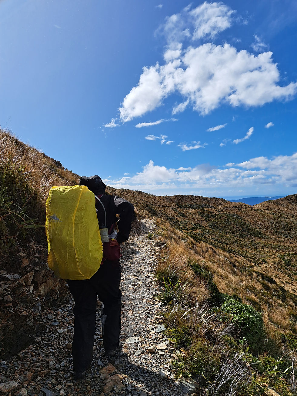
The shuttle arrives at 8am for the hour drive via Blackball to the start of the track at Smoke-Ho car park. Blackball is an old miner's town famous as the birthplace of the NZ political Labour party, but these days it is home to Blackball salami which we often munch on our hikes. The rain is persisting down and by 9am we are starting the 20km hike to Moonlight Tops Hut.

The first 10km section of the track takes us up through podocarp and beech forest towards Ces Clark Hut, our lunch stop. If you want, you could stay at Ces Clark the night adding another night to the Great Walk. Signs indicate it should take 4-5hrs and for the most part we are sheltered from the rain under trees for the ascent. The track is not steep but does have a steady incline most of the way as we pass ferns, palms and cascading rivers along the way. The track is wide and well-formed as the Paparoa track is one of two Great Walks that can be completed by mountain bike. The rain never really lets up and by the time we reach Ces Clark hut 4hrs later, we are ready to dry off, warm up, and chow down some food and hot tea. The hut is cool and rustic with sleeping and cooking areas in one room and a fireplace in the middle. We don't hang about too long as the small hut starts to fill with people, and we still have another 10km to crack on with.
We slip back into our rain gear and hoist our packs on knowing we have got most of the climb behind us. The next 10kms will see us traverse the ridge of the Paparoa Range for the next 3 hours towards our destination, Moonlight Tops Hut. The track is undulating and rocky underfoot from here but is well maintained and easy to navigate without much thought.
The Paparoa Great Walk opened in 2019 to commemorate the 29 miners who lost their lives at the nearby Pike River Mine explosion. The rain finally starts to ease after an hour, and the sun makes an appearance, rewarding us with rainbows and magnificent views across the Paparoa ranges and Tasman Sea.

It is very exposed up here and the wind has picked up pushing us around a bit but evidently helps to dry us out. The West Coast gets some wild weather from the Tasman Sea and caution would be required on this part of the track, particularly in challenging weather. It's rugged country up here and respect for mother nature would be wise. We round a bend just past the '1km to the hut marker' and are blocked from the wind's onslaught momentarily and realize how warm it is out of the wind. The views are unreal looking east to the Southern Alps from this spot and its smiles all round as we can see the hut nearby after a long day. Moonlight Tops Hut is perched perfectly on the mountainside with impressive views towards the ocean.

The hut is new(ish) and has a common room and two bunk rooms either side of a fire that is glowing hot as we enter, so everyone can dry their gear. The hut warden talks at 7pm and informs us the forecast is looking great for tomorrow. She cautions however that the weather can come in quickly and should you sustain an injury, be prepared to hunker down for some time until rescue teams can reach you. I imagine mountain bikers will have a greater opportunity for significant injuries coming off at speed during tomorrow's downhill descent. We side eye each other, grateful that we are just beating the feet this time.
Day 2 - Moonlight Tops Hut to Pororari Hut
The wind was thunderous, shaking the hut most of the night which made for a hectic midnight toilet trip. However, as the sun rose in the sky the winds gave way to a glorious morning on the mountain. It is definitely 'suns out guns out' and we are stoked to pack away the rain gear for the rest of the trip.

From the balcony you can see today's trail which will squirm us around the side of Mt Anderson and across the top of ridges, bending around to an emergency shelter at the halfway mark. On a clear day you can see it in the distance directly opposite Moonlight Tops Hut.

The hike today is expected to take around 5-7 hours as we travel a total of 19.1km to our final destination, Pororari Hut. The crew are in high spirits as the sun glistens down and we head off along the trail for today's adventure. The views are epic as you wind around the side of the mountain and then snake in and out of trees across the ridge line for the next10km.

After a couple of hours or so, we reach the emergency shelter and toilet sitting at a rocky outcrop, which is a great spot for lunch. From here we eventually descend into lush forest and weave our way through boulders and switchbacks until we come across a suspension bridge sitting under a waterfall.

A few mountain bikers respectfully slow down to give us time to jump aside and they look like they are having fun bombing the trail. The distance to Pororari Hut is long at just under 20kms but really enjoyable and a relatively straightforward day.
Pororari Hut has incredible views out to the sea and there is plenty of room for everyone to lounge on the balconies without feeling crowded.

We laze on the grass and enjoy a couple of drinks as a cheeky Weka bird starts stalking the perimeter. Without noticing, the Weka emerges from a bush with a half-eaten wormy morsel still in its mouth and drops its beak in an unattended whiskey. The Irish shoos the Weka away, reviews the cup, and then finishes the tainted whiskey before he gets ambushed again.

We have seen some incredible sights on the Great Walks but watching the blazing orange sunset disappearing into the sea, while simultaneously watching the moon rise from behind the mountain peaks was entrancing, and a total highlight of the trip.


Day 3 - Pororari Hut to Punakaiki
The final day of the Paparoa Track is expected to be uncomplicated as we descend through forest, heading towards Punakaiki over16km of track.

The track mostly follows the Pororari River towards the ocean and turns from a funky brown at the beginning to a beautiful turquoise once we enter the gorge. The gorge is breath taking with colossal stone cliffs and nikau palms giving it a prehistoric vibe.

The water looks so inviting and it has been a hot and sweaty day, so we send the crew nurse off to scout for a good swimming hole and lunch spot. She has taken a secret sidetrack down to the river that has become overgrown, and we hear her calling out telling us to follow. This is our first opportunity to swim on this Great Walk, and we don't hesitate to throw ourselves in the clear waters to cool off and munch some lunch.

We are careful not to take the inland track the mountain bikers use and continue through the gorge passing lots of day walkers. The gorge is stunning, and it would be amazing to kayak out from here to Punakaiki (maybe next time). The exit gates come far too soon, and we are sad to end this epic West Coast Great Walk. We head across the road to the garden bar, take off our boots, dump our packs, and order 18 pints of hazy pale ale. Figuring by the time they finish pouring them all, us thirsty hikers would have finished the first 9.


Comments